



We often, almost instinctively, associate cartography with the age of great geographical discoveries, marked by the discovery of the New World. In reality, this is not the case, for cartography never truly ceased to reflect the studies and ideas concerning the world in which people lived; consequently, the production of maps has continued since the most ancient times. Venice also played its part in this discipline, where a number of distinguished citizens devoted themselves to creating what might be described as true works of art, as well as geographical maps.
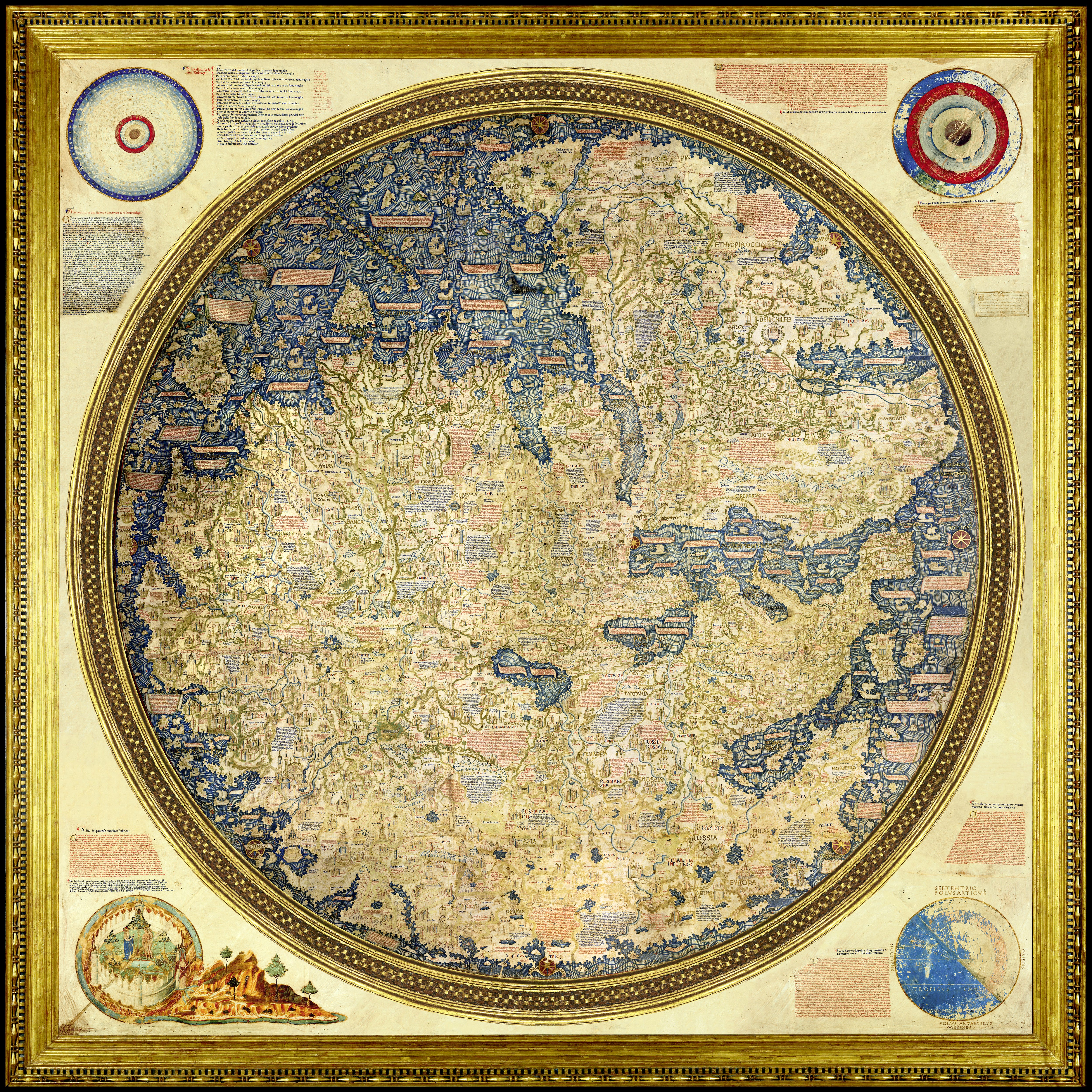
One such example is the world map attributed to Fra Mauro, now housed at the Marciana National Library in Venice, which stands as one of the finest cartographic achievements of the European 15th century. Created in the Camaldolese monastery of San Michel di Muran around 1450 – where Fra Mauro spent much of his life – this great planisphere emerged from the opulent Venice of great conquests and flourishing trade routes, at a time when the Republic’s gaze extended as far as the Indian Ocean. Museum and historiographical sources agree in presenting it as a work of exceptional ambition: the intention was, in fact, to create a truly cosmographic and even geopolitical project, given the emphasis placed by the Camaldolese monk on the oceanic routes that were opening up during those years.
Fra Mauro is one of the most significant figures in late medieval European cartography. Although biographical information is relatively scarce, documentary sources show him engaged in the intensive task of gathering and verifying available geographical knowledge, a task made possible by Venice’s privileged position as a crossroads for merchants, navigators, diplomats and travellers from Europe, the eastern Mediterranean and Asia. Far from being a mere copyist, Fra Mauro distinguished himself through his critical approach to traditional authorities, often preferring first-hand accounts and the most recent information to concepts inherited from antiquity. This intellectual openness enabled him to produce a representation of the world that was surprisingly up-to-date for its time, bringing together the experiences of Venetian merchants, the accounts of travellers such as Marco Poło, Niccłò de’ Conti and Piero Querin, and news from Portuguese explorations along the African coast.
From a compositional point of view, the world map was not a solitary endeavour. Fra Mauro worked with Andrea Bianco and other Venetian scribes and artists; accounting records also indicate that the task entrusted to the monastery was to produce a copy of a pre-existing cartographic model, accompanied by its accompanying texts. This fact tells us a great deal, because Fra Mauro’s work should not be understood as an improvisation or an exercise in style, but as a scholarly endeavour involving the collection, comparison and reworking of diverse bodies of knowledge. The most authoritative historiography notes, in fact, that the Venetian planisphere is itself a copy of an earlier model, now lost, and that its final form reflects a long process of revisions.
From a technical perspective, the map is striking for its physical construction: four large sheets of parchment are glued onto a wooden backing, reinforced at the back by cross-bars; the whole is set within a gilded circular frame (almost two metres in diameter), which is in turn enclosed within a gilded wooden square. Fra Mauro omits metric scales, course lines, directional lines, the equator and the tropics; the map is oriented with south at the top, a choice that breaks with the most widespread European conventions (derived particularly from the medieval tradition) and which reflects a different way of viewing the world. Eight compass roses mark the essential directional references, whilst cosmographic cartouches are situated in the four corners of the square frame: the heavens, the sublunary world, the elements and the Garden of Eden. These last four are cosmographic elements in relation to all the other cartouches within; in particular, the elements refer to theories of the Earth’s habitable zones, whilst the sublunary world presents the Aristotelian conception of the four fundamental elements (earth, water, air, fire), which Fra Mauro, however, arranges in concentric circles rather than according to the proportions of ‘importance’ dictated by the philosopher of Stagira.
The geographical content of the planisphere is equally innovative. Fra Mauro, as mentioned, constructed his image of the world by collating literary sources, accounts from travellers passing through Venice, and oral information. His interest was not merely antiquarian: the world map is a ‘cosmographic project’ that visualises the possibility of connecting the entire ecumene via oceanic sea routes. From this perspective, Cipango, Java and Zaiton appear, as do Aden, Hormuz, Mecca and, ideally, Venice and Lisbon. The work also suggests that the source of information from the Asian world is by no means marginal: Fra Mauro draws on Marco Polo, Odorico da Pordenone and Niccolò de’ Conti to describe Asia and South-East Asia, whilst for India and the Indian Ocean he also relies on recent descriptions and a network of mercantile and diplomatic contacts.
The African section of the world map is perhaps the most revolutionary. Fra Mauro explicitly records Portuguese voyages along the Atlantic coasts of Africa and states that he drew on Portuguese maps: this is the oldest known evidence of Portuguese cartography. By combining this information with accounts of the great Chinese junks (sailing vessels of the Ming period) that plied the Indian Ocean, he arrived at a theory that was extraordinary for its time: Africa could be circumnavigated and the Mediterranean could, in theory, be directly linked to the Indian Ocean. It is not yet the sophistication of sixteenth-century nautical charts, but it already represents a decisive departure from the closed and static geography of the more traditional Middle Ages.
Finally, there remains the most enigmatic chapter: that of the second globe. Archival sources indeed mention a copy intended for Alfonso V of Portugal, commissioned in 1457 and sent to Lisbon around 24th of April 1459 under the custody of Messer Stefano Trevisan; in fact, the monastery of Murano records the transaction in its registers as follows:
“Dom Nicholò [referring to one of the monks at the monastery] nostro me à dicto che essendo io a capitolo a Camaldoli, è stato saldà questa raxon a messer Stefano Trevixan per nome del dicto segnor [the king of Portugal] quando per el dicto messer Stefano li fo mandato el suo mapamund”
Our Don Nicolò told me that, while I was at the General Chapter [of the order] in Camaldoli, this account was settled with Messer Stefano Trevisan on behalf of the said lord, when the aforementioned Messer Stefano sent him his globe.”
Hower, this copy was subsequently lost and disappeared from the records. Modern studies suggest that the Murano workshop produced two almost identical copies: one, now preserved in Venice, and the other, the Portuguese one, which has vanished over time. It is precisely this loss that keeps the fascination of Fra Mauro’s globe alive: its greatness lies not only in the map we see, but also in the shadow of the other map, the one that Portugal received, and which time has swallowed up.
In any case, Fra Mauro’s globe remains the greatest ‘monument’ of late medieval cartography, not least because of its remarkable size, which even earned the praise of another great Venetian cartographer, Zuan Batista Ramuzio. Its development within the city of Venice, which, moreover, would mark the beginning of modern cartography, implicitly points to a high level of knowledge and innovation that found more than fertile ground in 15th century Venice, one of the most culturally significant European cities of the time.
Sources